

Danes Dyke – Flamborough – Beacon Hill Walk
Moderate Difficulty Walk of 3 miles Distance
Take a walk to the highest point on the southern headland, Beacon Hill, home to Beaker Man. You will follow field paths, minor roads and cliff top paths, and climb some steps.
Details for Danes Dyke – Flamborough – Beacon Hill Walk
- Reference: E4
- Circular walk: Circular
- Difficulty: Moderate
- Walk type: Coast and Beach Walks, Nature Trail and Country Park Walks
- Ordnance Survey Explorer Map: 301
- Car Parking Facility: Danes Dyke
- Refreshments: Cafe at Danes Dyke car park and pubs in Flamborough
- Public Conveniences: Danes Dyke, Flamborough North Landing
Further information
Features of interest
- Evidence of Mesolithic, early Neolithic and Beaker occupation has been found in this remote high place. It was probably a good vantage point and a place to fish and catch fowl. However, why settlers didn’t choose the sheltered, water-fed inlet at Danes Dyke remains a mystery!
- Part of the ground floor plan of an oval, timber-built Beaker house has been found and traces of Beaker Man are extremely rare in Great Britain. The Romans were possibly here using the high ground as a signal station, as 4th century pottery has been found and sandstone blocks similar to those at the Roman signal station at Filey unearthed during quarrying. The Romans established signal stations along the coast as threats from northern tribes and Anglo Saxon raiders increased.
- Beacon Hill takes its name from the beacons that stood there from the 16th century onwards. There were three on the headland in 1588. One was on the headland, one at the northern end of Danes Dyke and one at Beacon Hill, which still stood in 1834. They consisted of iron hoops holding iron pans and were lit to give warning of invasion, the Spaniards and their Armada being intent on a take-over. If one strange ship was sighted, one light was fired. For many strange ships, two lights were fired and for an actual invasion, all three were fired. A network of beacons existed on various high points inland to give warning to York. You lit your three pans and they shut the gates! In all, 52 beacons existed in the East Riding. After the Romans, the Vikings probably also used the high ground as a vantage point – and now you use it to admire the view. The Roman Galleys and Viking Longships have long gone, to be replaced with the sometimes raucous fishing parties with their crates of brown ale – have things changed?
Accessibility
The Danes Dyke – Flamborough – Beacon Hill Walk:– contains some gentle slopes.- contains stiles and steps.- contains surfaces which can be boggy in wet weather.
Additional information
– If you fancy refreshments, visit one of the unspoilt village inns which serve some of the best food in the area.
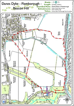
Download “Danes Dyke – Flamborough – Beacon Hill Walk” map
Locations
- Start point: Danes Dyke or Flamborough village
- End point: Danes Dyke or Flamborough village
- Towns and villages: Flamborough, Marton and Sewerby
- Parish: Flamborough
- Ward: Bridlington North
- Start Easting: 521,553.00
- Start Northing: 469,477.00
- End Easting: 521,553.00
- End Northing: 469,477.00
Distances
- Distance (miles): 3
- Distance (kilometres): 4.8
- Distance range: 0-5 miles


